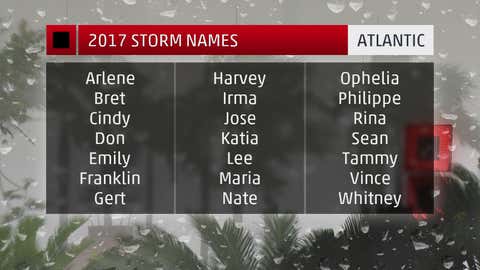
Thursday marks the official start of the 2017 Atlantic hurricane season. Tropical storm and hurricane activity during the six-month-long season typically reach a peak during the late summer and early fall, namely August into October.
While the ultimate outcome of any storms that form this year is unknown – except for one storm that already formed – there are six things you should know about the season ahead.
1. The Season Already Began
More than 40 days before the season's official start date, the first storm of the 2017 season developed in the northern Atlantic Ocean.
Tropical Storm Arlene was named April 20 and marked the first named storm to occur in that month since 2003. Arlene's formation began as Subtropical Depression One, which was designated on April 19. It then acquired full tropical characteristics about 24 hours later.
June 1 marks the official start of the season, but storms can form before that date. In fact, the last three years have featured these so-called preseason storms, including Tropical Storm Arlene (2017), Hurricane Alex (January 2016) and Tropical Storm Ana (May 2015).
2. 'Irma' Makes Its Debut on 2017 Named Storm List
The list of names being used in 2017 has one newcomer from when it was last used in 2011. This year's "I" storm will be Irma instead of the now-retired Irene used six years ago.
Hurricane and tropical storm name lists repeat every six years unless one is so destructive and/or deadly that a World Meteorological Organization committee votes to retire that name from future lists.
Irene first pounded the Bahamas and then made landfall in eastern North Carolina as a Category 1 hurricane on Aug. 27, 2011. It was at tropical-storm strength for its final two landfalls along the Northeast coast.
Inland rainfall flooding, particularly from New Jersey to New England, largely contributed to its $15.8 billion price tag.
Irene was responsible for 49 direct deaths during its lifespan: 41 in the United States, five in the Dominican Republic and three in Haiti.
The "I" storm has been retired 10 times throughout history, the most of any letter. Eight of those 10 have been retired since 2001, according to NOAA's Hurricane Research Division.

3. Two Major Changes to Know About
There are two major changes this year from NOAA that we could see used for the first time.
First, advisories can now be issued for systems before they even form, which will be dubbed "potential tropical cyclones" by the National Hurricane Center. This will only be done for systems that have a potential to develop and bring tropical-storm-force or hurricane-force winds to land areas within 48 hours.
The "potential tropical cyclones" will be treated like tropical depressions, named storms and hurricanes. The NHC will produce a forecast projected path, watches and warnings and text products, including a full discussion and the forecast advisory every six hours until the threat ends.
A second change: storm surge watches and warnings will now be issued for the U.S. coastline. They were implemented for the first time in 2016 on an experimental basis, but 2017 could be the first time we see them used as an official warning product.
According to the NHC, "Storm surge is often the greatest threat to life and property from a tropical cyclone, and it doesn’t always occur at the same times or locations as a storm’s hazardous winds."
For more details on these two major changes, see this link.
4. Forecasts Call For Above-Average Activity This Season
An above average number of named storms is expected this season, according to independent forecasts from The Weather Company, an IBM business, and NOAA.
While these forecasts project the number of storms expected to roam the Atlantic Basin in 2017, they don't tell us anything about what, if any, land areas would be affected.
It's impossible to project where any given storm will track this year; therefore, coastal residents should have a preparedness plan in place that includes a worst-case scenario every year.

5. The So-Called 'Major Hurricane Drought' Streak Continues
The U.S. has not seen a so-called major hurricane make landfall since Wilma in October 2005. A major hurricane is Category 3 or stronger on the Saffir-Simpson Hurricane Wind Scale.
Although this is statistically true, the term "major" is a bit misleading. That is because even tropical storms and Category 1 or 2 hurricanes can cause major damage.
Last October's Hurricane Matthew provided a vivid example of this when it curled parallel to the coasts of North Carolina and South Carolina as a Category 1. Torrential rainfall on the north and west sides of the hurricane resulted in deadly, record flooding in the Carolinas.
There are plenty more examples of tropical storms and hurricanes in recent years that caused major damage but weren't Category 3 or stronger.
6. Five Years Since Sandy
This October will mark five years since Superstorm Sandy pummeled the East Coast with damaging storm surge, high winds and even heavy Appalachian snow.
Sandy also fits the mold of a hurricane that wasn't technically a major off the East Coast with respect to its maximum sustained winds but still had extreme impacts.
The damage estimate for Sandy is $65 billion, making it the second-costliest hurricane in U.S. history.
As of last fall, some communities were still dealing with the effects of Sandy, and the Staten Island neighborhood of Oakwood Beach will never recover since homes would not have any protection from the ocean if they were rebuilt there.


