Share
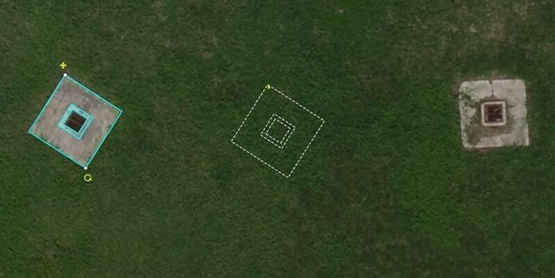
With the help of its industry-leading partners – photogrammetry software provider Pix4D, and the GNSS board and PPK provider Septentrio – WingtraOne PPK is now able to deliver orthomosaic maps and 3D models with an absolute accuracy down to 1 cm (0.4 in).
“With the latest upgrade, our drone WingtraOne PPK can offer something that has never been seen before in drone photogrammetry – broad coverage and high resolution at ultra precise accuracy. For example, in a single one-hour flight, the WingtraOne can cover 130 ha (320 ac), which is equal to 240 football fields and deliver maps at GSDs below 1 cm/px (0.4 in/px) with absolute accuracy down to 1 cm (0.4 in)”, explains the CTO of Wingtra Armin Ambühl.
These results are new to the industry – professionals could never reach such precision with any of the broad-coverage drones. Till now drone mapping world was mainly dominated by two types of drones: fixed wings and multirotors. Fixed wings can cover vast areas but cannot deliver extremely precise data. On the other hand, multirotors can deliver high accuracy but they only map small areas.
“Wingtra's advantage is twofold – VTOL (vertical take-off and landing) and the latest PPK technology,” adds Ambühl. “VTOL combines the best of both worlds: multirotors and fixed-wings. Vertical take-off and landing means hands-free operation and a smoother ride for the on-board sensors. Secondly, efficient flying in fixed-wing mode means far greater coverage than any comparable multirotor."
Post-Processed Kinematics — PPK — allows the WingtraOne to reach new level of accuracy. PPK computes ultra-precise geolocations for each image by combining the GNSS data with correction data from a nearby reference receiver. “We are truly excited to reach such unprecedented accuracy results. WingtraOne’s high payload capacity makes it possible to integrate the highest quality sensors: the Sony RX1RII and state-of-the-art Septentrio PPK system. An RMS error of 1.3 cm (0.5 in) horizontally and 2.3 cm (0.9 in) vertically without any ground control points is a significant leap forward in efficient aerial mapping, saving hours on the field”, says Ambühl. "We are very happy to offer such high resolution and high accuracy WingtraOne system for the demanding surveying industry.”
After the aerial data collection, Pix4D post-processing software steps in as a powerful tool to generate orthophotos and 3D models from the geotagged images. Ambühl comments that "after post-processing the data, results become visual — the orthomosaics and 3D models are extremely detailed and enable very precise calculations".
Wingtra team expects WingtraOne PPK to become the most desired drone in surveying and mapping applications. Maximilian Boosfeld, the COO of Wingtra adds, “Our unique VTOL technology has already helped us establish a firm ground in the market with applications ranging from cadastral surveying of Africa’s largest Uranium mine to digital elevation modelling of Alpine locations. With the combination of VTOL capability and the PPK, we see a clear advantage over the current aerial surveying solutions. I believe that WingtraOne will generally replace fixed-wings in large coverage mapping missions in the near future as we have just set the new industry benchmark in drone photogrammetry."
Subscribe to our newsletter
Stay updated on the latest technology, innovation product arrivals and exciting offers to your inbox.
Newsletter