Preserving the World’s Monuments, One Digital Scan at a Time
CyArk is traversing the globe in a race to digitally preserve the earth’s greatest heritage sites.
Climate-induced apocalypse forthcoming or not, our earth endures constant environmental stress. Our landscapes erode, our buildings and roads wear down and crumble. Sometimes humans exacerbate the stress; sometimes the structures simply surrender to the toll of Father Time.
CyArk wants to preserve our world’s important cultural heritage sites before they turn to dust. The nonprofit organization, based in Oakland, California, merges anthropological passion—some of its employees (there are just under 10) hold degrees in archaeology, architecture, or history—with new imaging technologies to steadily build a digital archive of the past, for the future. (The name CyArk is a combination of “cyber” and “archive.”)
“We operate in sort of two worlds,” says Elizabeth Lee, CyArk’s vice president. One entails cultural ministries and organizations such as UNESCO, academic institutions, and governmental boards of antiquities, which CyArk works with to get access to and learn about significant heritage sites around the world. The other is a more technical world in which the organization collaborates with data management and digital scanning companies, among others, using their technologies and products to capture and store data at a large scale.
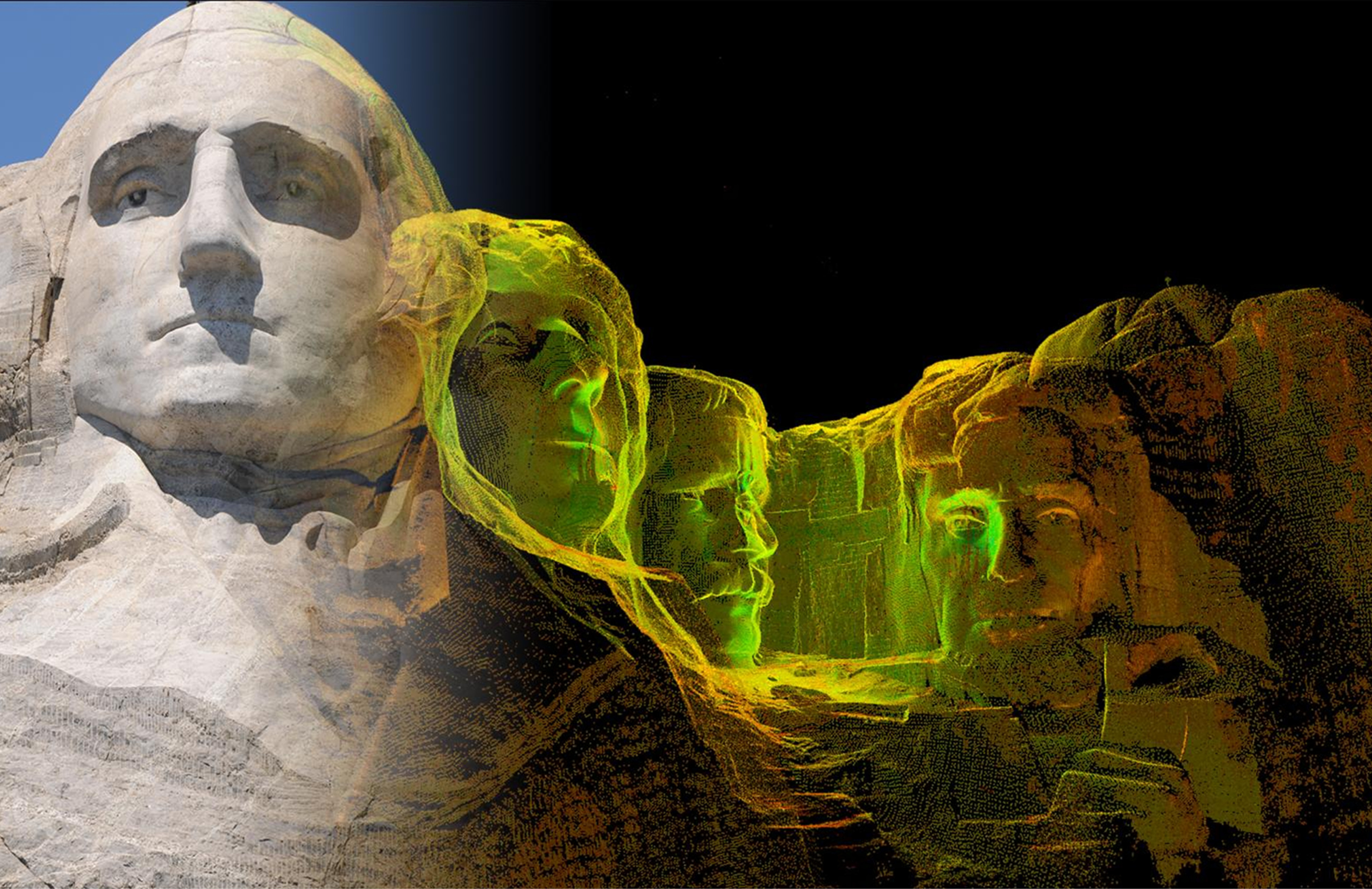
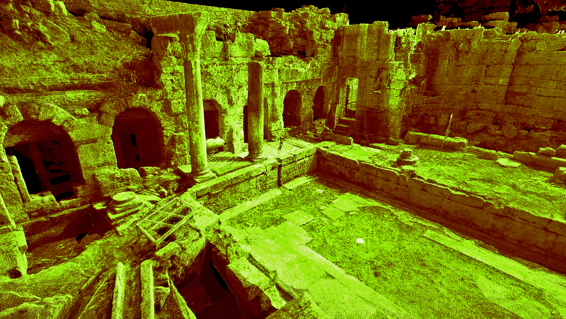
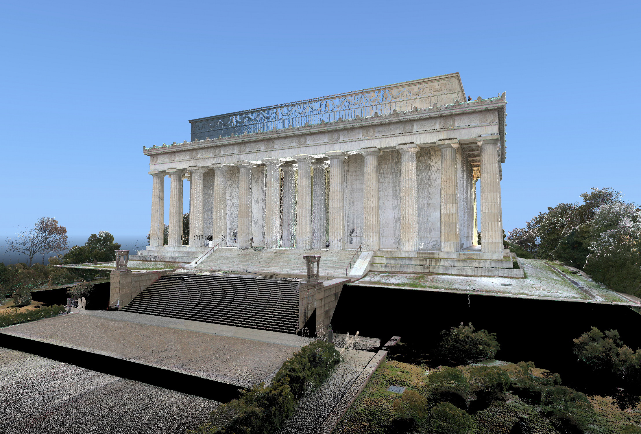
The end-product is high-resolution 3D scans of major sites and monuments around the world that enable users to virtually explore buildings and rooms and examine structural details throughout.
“This is the next best thing from reality,” says Ross Davison, field manager at CyArk. “So if you are trying to do analysis on a site, the idea is you can actually go in and virtually look at it [using our scans].” For instance, “if you’re a student who’s working in Germany and the site of interest to you is in South India, you should be able to look through the site with enough detail that whatever analysis you’re planning on doing, you could do it off of the point-cloud data.”
So far, CyArk has more than 200 sites archived in its database, including Mount Rushmore, the Tower of London, Pompeii, and Babylon. In 2013, it launched an initiative called the CyArk 500 Challenge, in which it plans to digitally preserve 500 sites over the course of five years.
A council of advisors—which includes members of UNESCO and ICOMOS (International Council on Monuments and Sites), and others—works with CyArk to evaluate sites on the list, which is constantly evolving.
“We look at three major factors in evaluating sites,” Lee says. “The first is risk: What sorts of risks are facing the site, whether it’s human-caused or potential natural disasters. Then we look at the significance of the site, accounting for both international, global significance as well as local, [and] importance within the community. Finally, we look at how the technologies that we use can be applied to benefit sites.”
This year, CyArk has been particularly focused on digitally preserving heritage sites in the Middle East. The challenge is “whether we can get to some of these sites before something happens—whether it’s the unrest and the intentional destruction of sites in Syria and Iraq, or even catastrophic natural events,” Lee says. “We are really in a race against time for some of these sites.”
When it comes to actually documenting a location, CyArk usually sends one or two team members into the field who work with the local government and site managers throughout the process.
The team uses a variety of technologies and tools while in the field.
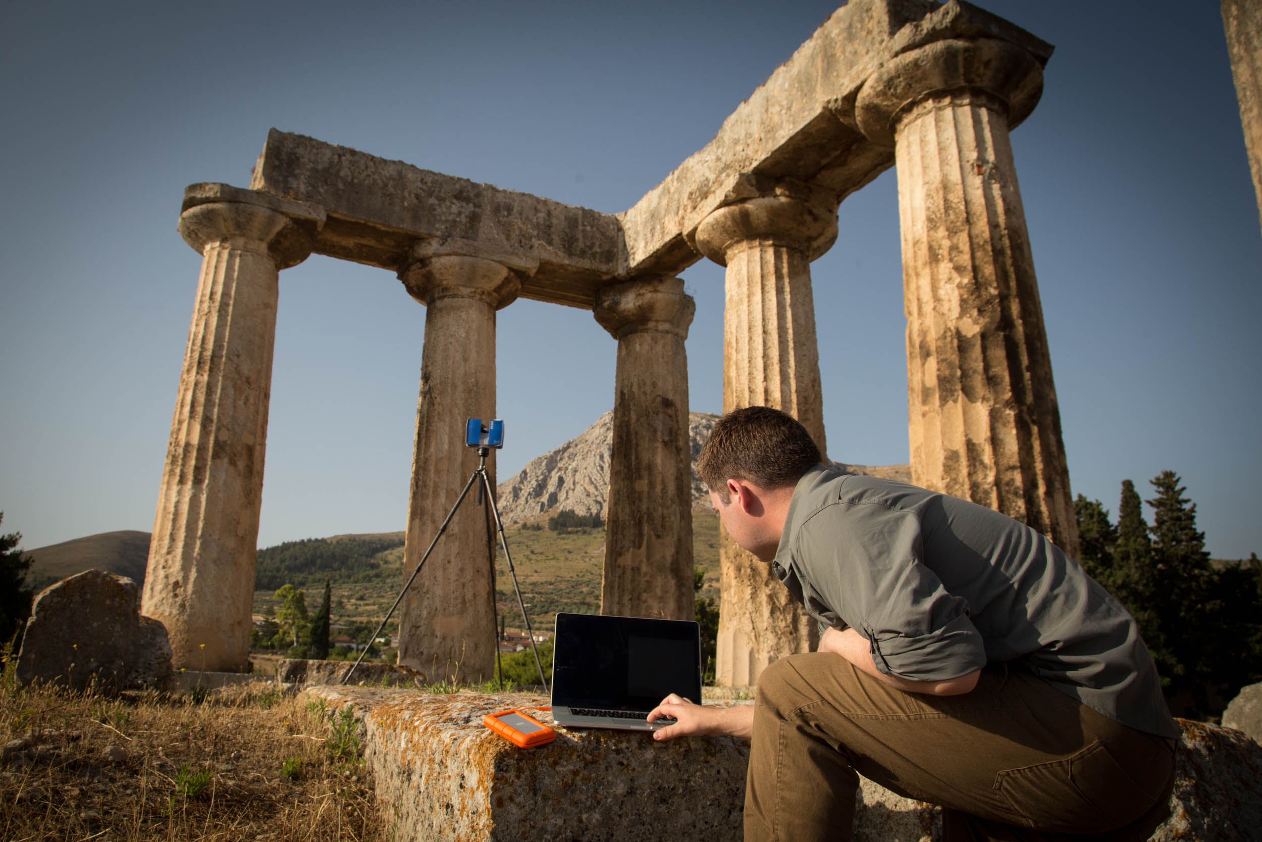
“One of our core technologies that we use is this 3D-laser scanning,” says Lee. The scanner sends out a pulsed laser beam of light that gets reflected back when it hits a surface, collecting individual data points every few millimeters that contain geospatial and color information. “It’s capturing hundreds of thousands of these a second,” she says.
CyArk will also employ photogrammetry (which entails taking a series of digital photographs of a subject, which they often do with a drone) and structured light scanning (used to capture highly detailed areas, like a relief)—all of which help to create detailed 3D representations of the structure and its surroundings.
Members of the CyArk team also chat with site managers and those who work at the locations to learn more about a given monument and collect anecdotal stories that might help flesh out the site’s history, according to Davison. In addition, CyArk might team up with local students and other organizations to train them on digital preservation so that they can continue collecting data and information about a site even after CyArk has left the field.
After the on-the-ground collection, the data goes into storage, archiving, and disseminating. Those in charge of the heritage site own the gathered data and can use it for their own purposes. But CyArk also uses the information to generate a number of resources—including interactive 3D models, animations, videos, and more (virtual reality is coming soon, the group says)—intended for public research and education.
National Mall and Memorial Parks staff in Washington, D.C., for instance, were enticed by the various opportunities that such data could provide, says the chief of partnerships, Robin Nixon. She first started talking with CyArk a few years ago, when the Washington Monument was undergoing its most recent repairs. At the time, “the assessment of the damage [to the monument] was done by going out—people on ropes, engineers hanging on ropes—[and] looking at the damage and comparing it to photographs with written notes, which was the record that we had,” Nixon says. “So when I saw the stuff that CyArk could do, I thought, you know, it would be a lot easier if we had a digital scan of the exterior and interior of the monument, and then we would be able to see when something was damaged—exactly what had changed since the time that we did the scan.” CyArk eventually scanned the Lincoln Memorial and Washington Monument.
In addition to making future maintenance easier, the data could also be used in STEAM curriculum for kids and maybe even as a resource for students of architecture and design, says Nixon.
“The data is an invaluable asset to preservation, which is of course, half of our mission. The other half is the education and enjoyment of our visitors,” says Nixon, “so [CyArk is] contributing to our overall mission.” The organization has opened “a whole new vista of opportunities to do creative things,” she says.
Public engagement is central to CyArk’s mission, too, says Lee.
“The sites and the monuments [of the world] are really the tangible links to our own history, and it’s critical that they’re able to be accessed by everyone,” she says. “In seeing this data, you can be virtually transported to these places, and you can get a sense of why they’re important and what they mean to people.”
Chau Tu is an associate editor at Slate Plus. She was formerly Science Friday’s story producer/reporter.