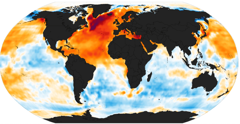
Ocean Multidecadal Oscillation (via NOAA)
The Pacific Ocean is warm. Very warm.
Last week, NOAA‘s U.S. Climate Prediction Center announced temperatures reached 3 degrees Celsius (5.6 Fahrenheit) above normal in a key section of the Pacific called Nino 3.4, touching off a Twitter typhoon among some El Nino watchers alarmed that they were so high. Monday, the agency said readings had edged up to 3.1 degrees above normal.
It’s probably too early to add this to the list of signs of the impending apocalypse. Instead, it’s likely just an indicator that the sea-surface component of El Nino is getting ripe, said Kevin Trenberth, senior scientist at the National Center for Atmospheric Research in Boulder, Colorado.
The weekly readings “are less reliable” than their monthly counterparts, which tend to be a bit cooler, he said. And El Nino isn’t just sea-surface temperatures: It’s also atmospheric changes that upend global weather patterns.
“Still, it shows a very warm Nino 3.4 region and a very strong El Nino,” Trenberth said.
Strong Nino
Since last spring, the world’s meteorologists have agreed an El Nino was under way in the Pacific, and have speculated that it might become one of the strongest on record. The weather-changing climate pattern has been blamed for an anemic Indian monsoon, a rash of Pacific hurricanes and typhoons and drought across East Asia.
Caution is probably the prudent course when looking at the weekly numbers for what climate scientists call ENSO.
El Ninos, and Pacific-cooling La Ninas, aren’t ranked according to weekly readings, said Michelle L’Heureux, a researcher at the Climate Prediction Center. Temperature measurements in the official record are done on three-month timescales.
“Short-term values are not just ENSO,” she said.
Numbers Skew
Weekly numbers can be skewed by wind, cloud and rain patterns above the ocean that allow parts of it to warm or cool from week to week.
The biggest value the weekly numbers provide is a steady stream of data that scientists can plug into forecast models to try to chart what El Nino will do next.
On Tuesday, the Australian Bureau of Meteorology issued an outlook saying the Pacific is probably reaching its warmest point and temperatures will start to decline in the first three months of 2016.
The Pacific will most likely return to a neutral state by June through August, according to a joint outlook from the U.S. climate center and the International Research Institute for Climate and Society at Columbia University.
In the meantime, the weekly numbers provide a bit of conversation fodder in North America as it waits for the impact of El Nino to arrive.
There is a lag of several weeks between when conditions in the Pacific peak and when El Nino makes itself felt across the continent. So in California, where El Nino is forecast to bring some drought relief, the proof of its intensity may not arrive for at least a few more weeks, if not months.
Until then, everyone will be watching the thermometers for any clue they can find.
By Brian Sullivan – ©2015 Bloomberg News
Unlock Exclusive Insights Today!
Join the gCaptain Club for curated content, insider opinions, and vibrant community discussions.

 Join The Club