
Newfield Bridge
Newfield Bridge | |
|---|---|
 Newfield Covered Bridge, February 2010 | |
| Coordinates | 42°21′47″N 76°35′28″W / 42.363°N 76.591°W |
| Crosses | Cayuga Inlet west branch |
| Locale | Newfield, New York |
| Official name | Newfield Covered Bridge |
| Characteristics | |
| Design | Town lattice covered bridge |
| Total length | 115 feet (35 m) |
| Width | 16 feet (4.9 m) |
| Clearance above | 9 feet 5 inches (2.87 m) |
| History | |
| Construction start | 1851 |
| Construction end | 1853 |
Newfield Covered Bridge | |
| Location | Covered Bridge St., Newfield, New York |
| Coordinates | 42°21′47″N 76°35′27″W / 42.36306°N 76.59083°W |
| Area | 0 acres (0 ha) |
| NRHP reference No. | 00000095[1] |
| Added to NRHP | February 25, 2000 |
| Construction cost | $800 |
| Location | |
 | |
Newfield Bridge is a wooden covered bridge over the Cayuga Inlet west branch. It is in Newfield, Tompkins County, New York. It is one of 29 covered bridges in New York State[2] and the oldest covered bridge in New York that continues to carry motor vehicle traffic.
It was added to the National Register of Historic Places in 2000.[1]
Gallery[edit]
-
 Bridge as viewed from observation deck
 -
 Plaque located inside bridge showing restoration date
 -
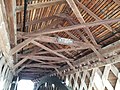
 Looking through the bridge, showing the truss and arch structure
 -
 Historic marker
 -
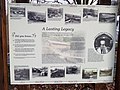 Interpretive signage


References[edit]
- ^ a b "National Register Information System". National Register of Historic Places. National Park Service. March 13, 2009.
- ^ Raymond W. Smith (December 1999). "National Register of Historic Places Registration: Newfield Covered Bridge". New York State Office of Parks, Recreation and Historic Preservation. Retrieved 2010-02-20. See also: "Accompanying five photos".
External links[edit]
![]() Media related to Newfield Bridge at Wikimedia Commons
Media related to Newfield Bridge at Wikimedia Commons
- Newfield Bridge, at New York State Covered Bridge Society
- Newfield Bridge, at Covered Bridges of the Northeast USA
| Topics | |
|---|---|
| Lists by state |
|
| Lists by insular areas | |
| Lists by associated state | |
| Other areas | |
| Related | |
This article about a bridge in New York is a stub. You can help Wikipedia by expanding it. |
Categories:
- Covered bridges on the National Register of Historic Places in New York (state)
- Bridges completed in 1853
- Wooden bridges in New York (state)
- Buildings and structures in Tompkins County, New York
- Tourist attractions in Tompkins County, New York
- National Register of Historic Places in Tompkins County, New York
- Road bridges on the National Register of Historic Places in New York (state)
- Finger Lakes, New York Registered Historic Place stubs
- New York (state) bridge (structure) stubs